


|
Using Analysis SST to clear residual cloud from MODIS SST dataAuthors: Yohanna W. Shaghude and Val Byfield
|

|
|
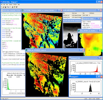
Screenshot from the lessons showing before and after (middle of the image), and some of the tools used to achieve theses results.
Satellite sensors that measure sea surface temperature (SST) at infrared (IR) wavelengths cannot 'see' through clouds. Where clouds are present, the satellites therefore measure cloud-top temperature instead of SST. On average, temperatures decrease by about 1°C for every 100m of altitude, so cloud top temperatures may be substantially lower than SST. Even small amounts of cloud can substantially reduce the apparent SST of a pixel.
This lesson shows how to carry out a screening of MODIS 1km SST images based on corresponding daily data from OSTIA. By the end of the lesson you should be able to:
- Screen the images visually to determine if there are areas where sub-pixel cloud has not been detected by standard processing.
- Extract the relevant region from global analysis data, resample and co-register this data to the MODIS grid.
- Modify and apply a threshold formula to mask pixels where MODIS SST is significantly lower than expected from the analysis data.
- Understand the principles behind the method, including potential problems and pitfalls.
Download the lesson:
Obtaining similar data
MODIS SST data at 1km resolution, based on the EAMNet data product can be downloaded from ChloroGIN Africa:
- Select the region you want from the map, and select the EAMNet option from the alternatives by clicking 'View'. This takes you to the data server maintained by the Remote Sensing Group at Plymouth Marine Laboratory.
- Where data is available, use the drop-down menu above the image to select MODIS SST.
- When the SST thumbnail appears, click on the image to see it in full resolution.
- Under the larger image, you will have the option to download the NetCDF data
OSTIA SST data at app. 6km resolution is freely available through the Copernicus Marine Environmental Monitoring Service (CMEMS) portal.
- Follow link to the on-line data portal and wait (ignore the message of 0 search results, the list of data sets take some time to download).
- In the search box that emerges, enter 'OSTIA' to see the SST products in this family.
Among the SST products listed The GLOBAL OCEAN OSTIA SEA SURFACE TEMPERATURE AND SEA ICE ANALYSIS at 0.05 x 0.05 degree resolution is similar to the OSTIA data provided with this lesson. It is avaialble from 2007 to present. The ESA SST CCI data gives climate quality SST data from 1991 to 2010. Both can be subsetted, allowing you to reduce the data volumes.
 Previous: MODIS flags
|
Last update: 01 April 2019 | Contact |  |
Site Policy |
Next: Weekly SST

|