


8. Mapping the major inshore marine habitats of the Caicos Bank by multispectral classification using Landsat TM
Author: Dr Alasdair J.Edwards, University of Newcastle, UK.
Aim of Lesson
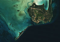
To learn how to undertake a simple supervised classification of a Landsat TM image to show the major marine and terrestrial habitats of the Caicos Bank.
Learning Objectives
- To prepare a mask for the land areas of the Landsat TM image and apply this mask to the depth-invariant bottom index images to be used for classification.
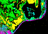
- To learn how to link UTM coordinate referenced field survey data of shallow water marine habitats to the Landsat TM image to derive simple spectral signatures for the major marine habitats (sand, seagrass, algae, gorgonian plain, coral reef).
- To understand the concepts underlying a simple box classification of marine habitats into sand, seagrass, algae, gorgonian plain, and coral reef, and perform the classification of each habitat in turn.
- To learn how to combine these separate images (GIS layers) into a single image and use an appropriate palette to display the habitats.
How to download the lesson
 Previous: Lesson 7
|
Last update: 20 August 2018 | Contact |  |
Site Policy |
Next: Lesson 9

|