|
1. Image files
Images:
atsr199701.gif atsr199801.gif Description
Download images
(195 K)
Useful information:
Image data: A grid of pixels
|
The grey-scale brightness of the image gives you a good indication of the relative temperature of different areas of the image.
However, if you want to know the temperature in the area represented by a particular pixel, you will need something a little
more exact. This page shows you how to find the digital value of individual pixels and using it to work out the temperature it
of that area. You will work mainly on the image from January 1997, so activate this image window now by clicking on it.
Pixel values on the status bar
To discover the exact value of any pixel, simply point to it with the mouse and click the left mouse button once to move the cursor to that point.
The cursor shows as a cross centered on the pixel you clicked on. The [x,y]
position of the pixel, and its integer value all show on the right side of the status bar of the Bilko application window (see
figure
(17K))
|
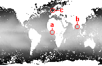
Question 1
In the image from January 1997 what are the pixel values and corresponding temperatures in the areas shown below?
(Try to avoid pixels next to a land pixel.)
|
|
a) Gulf of Guinea
b) Bay of Bengal
c) North Sea
Note:
The temperature will vary within each area, so a rough value will do; just point, click and look at the status bar.
Use the information from the image description
image description to convert from digital value to temperatue in °C.
|
|
|
Cursor moves
So far you have moved your cursor around by clicking your mouse on the image. You can also do this using the arrow keys on the keyboard:
| |  |
moves the cursor to the left |
| |  |
moves the cursor up |
| |  |
moves the cursor down |
| |  |
moves the cursor to the right |
Question 2
Move the cursor around using the keyboard arrows, noting its [x,y] position on the status bar. How many pixels does the cursor move with each key stroke?
You can move the mouse 1 pixel at the time by holding down the control
key while using the arrow keys (i.e. [CTRL+],
[CTRL+] etc. )
Finding a pixel with known coordinates
You will now find a pixel in the image Go To function. As most of Bilko's functions this can be accessed in several ways:
From the menu bar:
- either click on Edit, then Go To on the drop down menu,
- or hold down the [ALT] key and type E,
then type [G]. ( In short [ALT+E] > [G] ).
Mouse shortcut:
Right-click on the image (depress the right mouse button) and select Go To.
Keyboard shortcut:
Hold down the [CTRL] key and type G.
(In short [CTRL + G ] ).
Any one of these options will open the Go To dialog (
figure
(6K) ).
This allows you to set the [x,y] position of the pixel you want to find:
-
Enter the [x,y] coordinates into the two Position boxes.
-
Set the Selection Type;
to find a single pixel (a point) choose Point Selection
using the drop-down arrow to the right of the selection box.
-
Click OK to accept the settings.
Note:
The Go To dialog also allows you to set the increment of cursor moves.
The Normal box sets the increment for each arrow key stroke (10 by default).
The Control box sets the increment for cursor movements made by holding
down the control key while using the arrow keys (1 by default).
| | |
Activity / Question 3
In the January 1997 image, practice by moving to the coordinates below.
Where do they take you? What is the data value of each pixel? What is the sea surface temperature?
|
| a) |
[x,y] = [396,106] |
| b) |
[x,y] = [448,236] |
| c) |
[x,y] = [330,212] |
Pixel coordinates and the zoom function
|
|
Answers:
(Resizable
pop-ups)
Answer 1
Answer 2
Answer 3
Answer 4
Answer 5
Back up to:
Q1
Q2
Q3
Q4
|
|
Activity / Question 4
Try the following to check how the zoom function affects the pixel coordinates.
|
a)
|
In the January 1997 image go to position [x,y] = [180,130]. Where in the world did this take you?
|
b)
|
Zoom out to 50%. Make a note of the coordinates. What are they now? How do you explain this?
|
Pixel coordinates in sampled images
|
Activity / Question 5
In section 1.1 you learnt how to open an image at reduced resolution by sampling it;
the January 1998 image was sampled at a rate of 2,2. To see how sampling affects the
coordinates activate the January 1998 image and go to the position you used in question 4:
[x,y] = [180,130].
|
a)
|
Where in the world does this take you?
|
b)
|
How would you explain this difference from the January 1997 image?
|
Before you continue close the January 1998 image, but leave the 1997 image open for the next subsection of the tutorial.
|


)