


|
|||
Lesson 3: Sea surface temperature from AATSR |
|||
|
|
|||
|
|
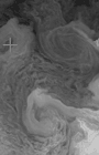
The Advanced Along Track Scanning Radiometer (AATSR) is the third in a series of highly accurate satellite infrared radiometers designed to measure the sea surface temperature to an accuracy of 0.3K for climate change detection and monitoring assuming <20% of the measurements are corrupt by cloud over an area 0.5° x 0.5°. Very high levels of accuracy and precision are required to support global climate monitoring and change detection. Because of this, the AATSR programme aims to maintain an instrument stability of 0.1K during the mission lifetime. Remote sensing and in situ experiments have shown over the last decade that mesoscale variability plays a major role in the character of Mediterranean Sea surface Temperature (SST). The thermal dynamics of this region are complex and depend on the interaction between the general circulation of the Mediterranean Sea (largely driven by thermohaline circulation), solar warming (leading to strong diurnal stratification), and the surface wind field. This Bilko lesson will explore wonderful thermal imagery obtained by the ENVISAT Advanced Along Track Scanning Radiometer (AATSR) instrument in the Balearic and Algerian basin area. It is designed to provide oceanographers and artists alike with an unprecedented and privileged view of the thermal characteristics of the ocean surface. |
||
|
|
|
||


|
|
|
|