
|
|
Platform and operating system
Bilko v 3 is designed to run on PCs running Windows 2000 and Windows XP, but will also run on Windows 95, Windows 98 and Windows NT 4.0 or later.
Software features
The latest version, currently under beta-testing, has been substantially extended and improved.
The new software now features:
 |
Support for common image formats used in remote sensing
MORE
|
| |
Handling of 3-D and multiband data (up to 64 channels)
MORE
|
| |
Support for 8-bit, 16-bit, 32-bit and floating point data
|
| |
Support for NaNs and customer defined Null values
|
| |
Image manipulation and display tools:
|
|
Contrast stretching
MORE
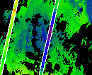
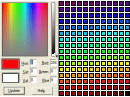
Applcation and design of colour palettes
MORE
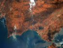
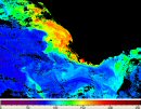
Display and creation of colour composites
Zoom, Mirror, Flip and 180o rotation
Colour bar, scroll-bars and status-bar displaying pixel information
Customised display of 16-bit, 32-bit and floating-point data
Extract tool for sub-sampling in the X, Y and Z dimensions
|
| |
Image editing and analysis tools:
|
|
Animations
Easy selection of specified points, lines and sub-areas
Data-coring (spectral or time series)
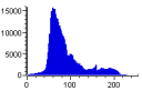
Transects, histograms, scatter-plots, Hovmöller diagrams
Principal Component Analysis
|
| |
Data processing tools:
|
|
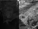
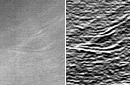
Predefined and custom designed filters
MORE
Application of flags, masks, and coastlines
Image calculations using formulae with sets of images
MORE
Image rectification, resampling, and co-registration
Geocorrection using Ground Control Points or tie-point tables
Automatic geocorrection of Envisat data
( MERIS, ASAR, AATSR, RA-2 )
|
| |
Export to ASCII (text/spreadsheets) via the Windows clip-board
|
| |
Context sensitive help program
|
|