


|
|||||||||
4.4 Western boundry current variability. |
|||||||||
References:
Downloads: |
The Gulf StreamThe location and variability of the of the Gulf Stream and Labrador current is an interesting case study. The Labrador Current is the "southward" flowing component of the N. Atlantic subpolar gyre. It transports cold waters into the warmer region of Gulf Stream rings and meanders. It flows south eastward from Hudson Strait (60°N) along the continental slope to the Tail of the Grand Banks (43°N). 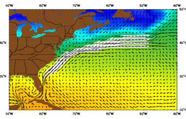 The Gulf Stream as represented by the Mariano Global Surface Velocity Analysis (MGSVA). The Gulf Stream is the western boundary current of the N. Atlantic subtropical gyre. It transports significant amounts of warm water (heat) poleward. Averaging the velocity data from a meandering current produces a wide mean picture of the flow. The core of the Gulf Stream current is about 90 km wide and has peak velocities greater than 2 m/s (5 knots). MORE The Gulf Stream begins in the Caribbean and ends in the northern North Atlantic. This extensive western boundary current plays an important role in the poleward transfer of heat and salt, and warms north-west Europe. The Gulf Stream begins upstream of Cape Hatteras, where the Florida Current stops following the continental shelf. The position of the point at which the Gulf Stream leaves the coast changes throughout the year. In the fall, it shifts north, while in the winter and early spring it shifts south (Frankignoul et al. 2001). Compared with the width of the current (about 100-200 km), the range of this variation (30-40 km) is relatively small (Hogg and Johns 1995). However, recent studies by Mariano et al. (2002) suggests that the meridional range of the annual variation in stream-path may be closer to 100 km. See HERE for more details (from http://oceancurrents.rsmas.miami.edu/atlantic/gulf-stream.html). Using the tutorialActivity Create a Hovmöller diagram along the Transect [42°45`N 69° 45`W] to [30°15`N, 69° 45`W]. This transect includes the dynamic hot Gulf stream core and the Cold Labrador current. Hint:
remember to properly adjust the y-axis and interpret the Diagram in the correct manner with respect to time - use the data gap in the ASST data as a guide.
|
||||||||
|
Answers:
Back up to: |
|
||||||||
|
|
||||||||


|
|
|